MAHDAVI-SAR -Search and Rescue Model and Response System
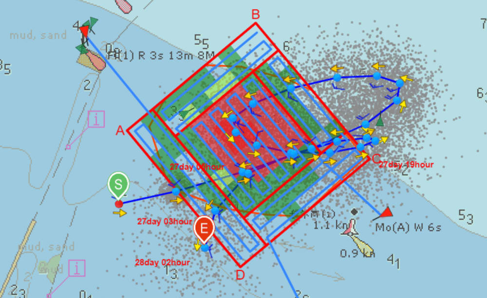
When objects are missing in a marine environment, whether it is missing vessels, missing persons or containers, a primary concern is where these objects will travel and where is the most probable search area. This must be done in an extremely time-effective manner as these are often life and death situations. MAHDAVI-SAR is a user-friendly, Windows-based search and rescue model system that provides rapid predictions of the movement of drifting objects and missing persons in marine, fresh water and aeronautical environments. MAHDAVI-SAR includes the ability to deploy search & rescue units (SRUs) with search patterns and calculate probability of containment (POC), probability of detection (POD), and probability of success (POS) based on the IAMSAR Manual guidelines.
It includes simple graphical procedures for specifying search and rescue incidents and entering both wind and hydrodynamic data. For over 25 years MAHDAVI-SAR has been used by Coast Guard agencies, Naval departments and international governments to successfully support search and rescue response, planning and drills/exercises in over 173 countries. MAHDAVI-SAR outputs an intuitive graphical overview of the search object trajectory so operators can easily deliver search area information to on scene assists.
Features of MAHDAVI-SAR
- Model output animation using RPSTimeslider.
- Search object database (101 water objects, 27 aeronautical objects).
- Search and Rescue Unit (SRU) database populated by users.
- IAMSAR and Monte Carlo methods for computing drift.
- Online basemaps. Open Street Maps, Demis and more.
- Supports commercial nautical charts. Search Planning Tool for SRU deployment
- Seamless access to Environmental Data Server for real time forecast data.
- Search and rescue scenario reportgeneration
- Model output AVI creation
- Time Series MS PowerPoint generation
- SRU text reporting (ASCII, Notepad,Word, etc.)
- Online download of software installations, patches and updates
- License options: USB Dongle, Software Key or Server License
Met-Ocean Data Integration
The Environmental Data Server (EDS) collects a wide variety of oceanographic and meteorological data that is used for marine response and crisis management as well as providing superior data sources to environmental modeling applications. EDS provides real-time and historical environmental data management, analysis, visualization and internet-based distribution through Web services. EDS connects regional data to operational users. The system collects scientific data in disparate formats and makes it available to operational users via standard web services.
TimeSidor and Real-Time Oata Linka
CMAP Nautical Charts
Applications of MAHDAVI-SAR
Calculate the drift of missing vessels, persons or objects (i.e. debris) at sea either forwards or backwards in time; Calculate the probable search area: Store home base locations of all available
able search and rescue u (SRUs):
Search and rescue unit search pattern management; and deployment and Calculate aeronautical drift of an aircraft and/or parachute resulting from an aircraft casualty (i.e. engine failure).
more information
Mahdavi_m_g@yahoo.com
Store Search and Rescue Units (SRUs) home base locations and properties.
Deploy SRUs to a model or user defined search area.
Deploy assets using a variety of pattern types.
Combine multiple resources for a single or multiple search target(s)
Like this entry?
-
About the Entrant
- Name:Nikoosar Maritime Aviation
- Type of entry:individual
- Patent status:pending