


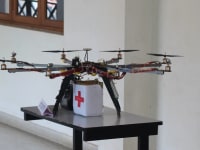

Conventional methods of surveying land consume a lot of time and are thereby quite expensive as it requires skilled personnel and manual labor. Inspecting larger areas at a shorter time is quite difficult to accomplish manually.We aim to solve this problem by using Drones for Aerially Mapping and surveying huge areas of land within a very short span of time. Data is acquired aerially, is processed as is given in a report like format. This report contains valuable Geospatial Data suited for survey calculations. The report is in a workable format and thereby can be used to generate 3D models, Orthomosaics, Contour Maps and Point clouds.The growth of the field of Robotics and the urge of the people to have fully automated equipment is being increased day-to-day and this gave us the idea. Team Dronix has a very strong technical background and has high end Unmanned Aerial Vehicles for various applications. The design is made in such a way that the aerodynamics is not altered which thereby increases the flight time and weight lifting capacity and thereby increases the overall efficiency of the system. The material used for fabrication is carbon fiber and is hence light in weight but also has a very high tensile strength and is thereby break-proof.
Video
Like this entry?
-
About the Entrant
- Name:Ranjith Samuel
- Type of entry:teamTeam members:Ranjith Samuel S
Ganesh Subramanian
Simeon Jebaz Asir
Hemanth M
Prithiviraj A - Patent status:none