
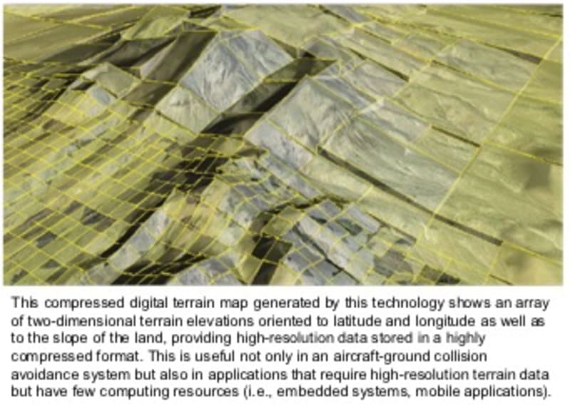


Capable of encoding massive amounts of data into a package more than 1,000 times smaller than with standard compression, this technology is poised to revolutionize the use of digital terrain maps (DTMs) in restricted environments (e.g., tablets, smart phones, embedded systems).
Developed at NASA’s Armstrong Flight Research Center, this software system integrates innovative encoding and decoding algorithms to provide (1) a 5,000:1 compression ratio and (2) rapid/continuous decompression in constrained computing situations. It enables users to access and create customized DTMs from a variety of data sources using a single, easy-to-use graphical user interface.
To fully understand the significance of this technology’s dramatic capabilities, consider the application for which it was originally developed: preventing aircraft collisions with the ground. Developed in collaboration with the U.S. Air Force, this innovation was created to locally decode and render DTMs for high-performance military airplanes needing automatic course correction in response to unexpected/dynamic events.
The technology’s extraordinary capabilities enable an aircraft-based system to:
-- Provide access to DTMs with significantly higher fidelity than ever before
-- Store a greater number of DTMs, covering an entire continent or even the entire world
-- Decompress those DTMs more rapidly than was previously possible, providing real-time rendering of a continuously updated local map
Standard compression methods provide only a 4:1 compression ratio—that is, the original file size is reduced only by one-fourth. In an aircraft—or in other computing-constrained environments—this shortcoming in compression capability limits the number of DTMs that can be stored locally at any one time. In the case of an airplane, technicians must swap out the DTMs in between flights, which introduces the opportunity for human error and requires extensive manual quality-control work.
NASA’s technology can compress extensive DTMs at the highly efficient ratio of 5,000:1. Compared to the standard 4:1 ratio, this compression ratio is enormously more effective. For example, a 22-megabyte (22 MB) DTM that previously could be compressed only down to 5.5 MB can now be shrunk to a miniscule 4.4 kilobytes (4.4 KB).
Although aviation is the original target for this valuable technology, NASA’s software has a wide range of applications. It is useful in any computing-constrained, real-time, embedded environment where both significant compression and very fast local decompression are needed. This includes situations where line-of-sight needs to be rapidly computed, where continual surfaces need to be analyzed, and/or where terrain routes need to be analyzed and planned.
Potential applications include:
-- Automotive global positioning systems (GPS)
-- Geographical prediction and planning (wind turbines, watershed, weather, urban planning)
-- Marine charting systems
-- Geospatial/Geographic information systems (GIS)
-- Medical software
-- Earth science data collection
-- Gaming systems
-- Software that analyzes 3D continual surfaces
-- Software that analyzes and plans terrain routes
As a single example, the software is forming the basis for an intelligent cruise control that would achieve better fuel economy in cars.
-
Awards
-
 2016 Electronics Category Winner
 -
 2016 Top 100 Entries
Like this entry?
-
About the Entrant
- Name:Mark Skoog
- Type of entry:teamTeam members:Shaun McWherter, NASA Armstrong Flight Research Center
Mark Skoog, NASA Armstrong Flight Research Center
Jamie Willhite, NASA Armstrong Flight Research Center
Loyd Hook, University of Tulsa (formerly NASA Armstrong Flight Research Center) - Patent status:patented